
Introduction: A Province Under Smoke
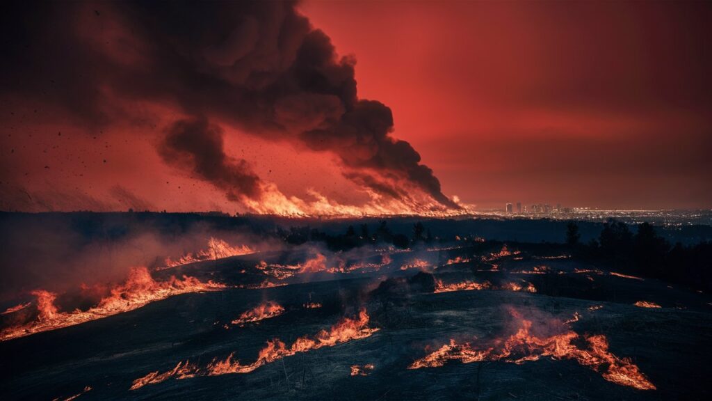
Ontario finds itself engulfed in an unprecedented wildfire emergency as the 2025 fire season escalates with terrifying speed. What began as scattered blazes in early May has exploded into a full-scale ecological and public health crisis, blanketing communities in toxic smoke, forcing thousands to flee, and stretching firefighting resources to their absolute limits. Against a backdrop of climate-induced drought and extreme heat, these fires are not merely burning forests—they’re reshaping skies, threatening cities, and exposing the fragile line between human settlements and increasingly volatile natural systems. With smoke now drifting across borders and colliding with transcontinental dust plumes, Ontario’s fires have become North America’s problem.
1. Current Fire Situation and Critical Incidents
Ontario’s Northwest Region is ground zero for the most severe fire activity, where multiple out-of-control blazes are consuming vast landscapes and threatening communities:
- Red Lake 12 (RED012): A monstrous 17,987-hectare inferno near Deer Lake First Nation, where smoke has reduced visibility to just one kilometer, repeatedly grounding aerial firefighting operations. Fire crews are racing to install protective sprinkler systems on community buildings amid dangerously volatile conditions 3.
- Nipigon 5 (NIP005): A 7,506-hectare fire menacing Webequie First Nation, where crews are establishing hoselines and structural protection as the fire exhibits aggressive behavior. The situation remains precarious despite expected rainfall 3.
- Kenora Complex: A multi-fire nightmare including the 35,426-hectare Kenora 20 fire that has crossed into Manitoba, and Kenora 32 burning 7,716 hectares within Woodland Caribou Provincial Park. Emergency Implementation Orders have triggered mandatory evacuations and prohibited access to Crown land across vast areas 312.
Table: Major Active Fires in Ontario (as of June 3, 2025)
| Fire Name | Size (Hectares) | Status | Location/Impact |
| Red Lake 12 | 17,987 | Not Under Control | Threatening Deer Lake First Nation |
| Nipigon 5 | 7,506 | Not Under Control | Near Webequie First Nation |
| Kenora 20 | 35,426 (total) | Not Under Control | Crossed into Manitoba |
| Kenora 32 | 7,716 | Not Under Control | Woodland Caribou Provincial Park |
| Sioux Lookout 3 | 1,849 | Under Control | North of Savant Lake |
| Fort Frances 4 | 3,593 | Being Held | North of Crystal Lake |
2. Historical Context and Seasonal Evolution
The 2025 fire season represents a devastating escalation from the previous year. While 2024 saw a relatively mild season with only 480 fires burning 89,841 hectares—well below the ten-year average—the current crisis has already eclipsed those numbers with terrifying speed 7. This dramatic swing aligns with climate scientists’ warnings about increasingly volatile fire weather patterns. The season ignited with a cruel twist: “Zombie fires” that smoldered underground since 2023 resurfaced in Alberta and British Columbia, marking the first known instance of fires surviving through two Canadian winters 4. By late May, national burned area reached 1,078,697 hectares—more than double the ten-year average—with Ontario’s Northwest Region accounting for over 69,000 hectares alone during the previous season, setting the stage for this year’s explosive growth 712.
3. Causes and Contributing Factors
Ontario’s wildfire crisis stems from a dangerous convergence of natural and human factors:
- Climate Amplification: A winter of diminished snowfall and record-breaking spring heat created ideal combustion conditions. Winnipeg’s May 13 temperature hit 37°C (99°F)—shattering a 125-year record—while Labrador’s snowpack measured just 257 cm compared to 388 cm the previous winter 410. These anomalies left forests primed to burn.
- Human Ignition: Escaped debris burns continue to spark catastrophic fires, exemplified by the May 31 multi-structure blaze near Sage Road caused by inadequately extinguished embers 8. The Ontario government’s proposed legislative overhaul acknowledges this persistent threat through stricter penalties for fire regulation violations 9.
- Drought-Fueled Spread: The Canadian Wildland Fire Information System identifies western Ontario, Manitoba, and Saskatchewan at “Extreme Risk” (Level 5/5) due to tinder-dry conditions that allow fires to spread rapidly and resist containment 11. This classification reflects how easily vegetation ignites, how intensely fires burn, and how difficult they become to control—all metrics now maxed out across the region.
4. Multi-Provincial Response and Firefighting Operations
Canada has escalated to National Preparedness Level 5—the highest emergency designation—indicating complete resource commitment and the need for international assistance 12. Ontario’s response reflects this all-hands approach:
- Resource Mobilization: FireRangers are implementing structural protection measures in threatened First Nations, deploying sprinkler systems around critical infrastructure, and establishing hoseline perimeters. The province has activated four additional medium-lift helicopters this season, bringing its aerial fleet to 13 aircraft 79.
- Interprovincial and U.S. Cooperation: Saskatchewan and Manitoba have joined Ontario at Agency Preparedness Level 5, triggering resource-sharing through the Canadian Interagency Forest Fire Centre (CIFFC). The U.S. Forest Service has deployed air tankers and 150 firefighters across the border, while Alaska, Oregon, and Arizona have contributed crews 1012.
- Restricted Fire Zones (RFZs): Two major RFZs are in effect across northwestern Ontario (Zones 2,3,6,7,8 under RFZ 2025-001; Zones 4,9,10,11 under RFZ 2025-002), suspending all open burning including campfires 12. These drastic measures aim to prevent new human-ignited fires during peak danger.
5. Health Impacts and Air Quality Crisis
Wildfire smoke contains particulate matter (PM2.5) that penetrates deep into lungs and bloodstreams, triggering respiratory distress and exacerbating heart conditions, diabetes, and other chronic illnesses 1. The crisis reached horrifying visibility on June 3 when Minneapolis recorded Air Quality Index (AQI) values exceeding 250—categorized as “Very Unhealthy”—briefly giving it the second-worst air quality globally after Kuwait City 111. This smoke event is now evolving into a complex atmospheric phenomenon:
- Continental Smoke Transport: Upper-level winds have carried smoke plumes over 3,000 miles across North America, triggering air quality alerts from Manitoba to the Gulf Coast. Northern Minnesota recently experienced “Hazardous” (AQI 300+) conditions—the most severe designation 11.
- Saharan Dust Collision: A trans-Atlantic dust plume from Africa’s Sahara Desert is approaching the southeastern U.S., where it may interact with lingering Canadian smoke. This collision could further degrade air quality while creating unnaturally vivid sunrises and sunsets through atmospheric scattering 1.
- Vulnerable Populations at Risk: Indigenous communities and evacuees face compounded health threats. With hotels overwhelmed, thousands have endured nights sleeping on floors or in hallways. “People are tired,” acknowledged Assembly of Manitoba Chiefs Grand Chief Kyra Wilson during one of Canada’s largest evacuations since the 1990s 10.
6. Future Preparedness and Policy Shifts
Ontario is pursuing legislative and operational reforms to confront the “new abnormal” of extreme wildfires:
- Resource Management and Safety Act: This proposed law would modernize the outdated Forest Fires Prevention Act (last updated in 1999) by mandating comprehensive wildland fire management plans, introducing modern enforcement tools, and imposing stricter penalties for violations 9.
- Enhanced Firefighting Capacity: The province’s $64 million investment funds nearly 100 new permanent fire management positions, emergency management software upgrades, fuel systems, and fire suppression equipment 79.
- Risk-Informed Development: MyChoice’s 2025 wildfire risk assessment shows western cities (Kamloops and Kelowna, BC) at highest risk (9.2/10), though Ontario’s Kenora has seen increased vulnerability (6.2, up from 5.4). This data informs insurance markets and community hardening strategies 14.
Conclusion: Living with Fire in a New Era
Ontario’s 2025 fire season has become a brutal case study in climate disruption, revealing how drought, heat, and historical land management practices have converged into catastrophe. As fires merge into mega-blazes and smoke chokes continents, the crisis demands more than emergency response—it requires fundamental rethinking of forest management, community planning, and cross-border cooperation. The proposed legislative reforms and resource investments mark necessary steps, but true resilience will emerge only when we acknowledge wildfires not as isolated disasters, but as year-round, permanent features of our changing landscape. In this era of ecological unraveling, Ontario’s smoke-darkened skies serve as both warning and call to action: adapt or face irreversible consequences.
Frequently Asked Questions: Ontario Wildfires 2025
1. What caused Ontario’s 2025 wildfires?
The fires stem from climate-amplified drought, record heat, and human activities. Winter’s diminished snowpack and spring’s extreme temperatures (Winnipeg hit 37°C/99°F in May) created tinder-dry forests. Human ignitions—including escaped debris burns like Ontario’s May 31 multi-structure fire—account for many starts, though lightning also plays a role 4810.
2. How is smoke affecting air quality and health?
Smoke carries hazardous PM2.5 particles that penetrate lungs and bloodstreams, worsening respiratory/cardiac conditions. Minneapolis recently hit “Very Unhealthy” AQI levels (250+), ranking among the world’s worst air quality. At-risk groups (children, elderly, those with pre-existing conditions) should limit outdoor exposure and monitor AirNow.gov forecasts 111.
3. Which communities are currently evacuated?
Mandatory evacuations include Webequie First Nation (Nipigon 5 fire), areas near Deer Lake First Nation (Red Lake 12), and zones under Kenora Implementation Orders. Cross-border evacuations have also occurred, with Manitoba relocating ~17,000 people, including all of Flin Flon and Cranberry Portage 31012.
4. How can residents protect homes from wildfires?
Create defensible space by clearing dry brush, trimming trees near structures, installing fire-resistant roofing/siding, and storing flammable materials away from buildings. The Association of Manitoba Chiefs also urges communities to establish evacuation plans acknowledging potential hotel shortages 1014.
5. What long-term solutions are being implemented?
Ontario’s proposed Resource Management and Safety Act would modernize fire prevention laws and enforcement. The province has also invested $64 million in firefighting resources, including 100+ new positions and 13 contracted helicopters. These measures aim to enhance response capacity amid worsening fire weather 79.